The TDS Race – Ultra-Trail du Mont-Blanc


The TDS  (Sur les Traces des Ducs de Savoie) is one of the five UTMB races and is classified as difficult. It’s known as the wild alternative to the CCC and UTMB and is a highly technical race set in the remote and picturesque surroundings of the Italian and French Alps.


Race Statistics

119km (73.9 miles) in length with 7,250m (23,786 feet) of height gain

  • Number at the start: 1794 including 174 women (9.70% of participants) 
  • Number of finishers: 1060 (59.09% of participants) including 111 women (10.47% of all finishers) (63.79% finishing rate for the women) 
  • Total number of DNFs (Do not finish): 734 (40.91% of participants)

My alarm clock went off at 2.45am and it felt like I’d hardly slept at all. I was nervous and  had packed and repacked my rucksack the previous day so I knew I had plenty of time to get ready without rushing. I got on the bus at 3.50am for the 40 or so minute journey to the start, which went through the Mont Blanc tunnel to Cormayeur. The bus dropped us all off at the Leisure Centre, which was a sprawling mass of runners who were either sat or lying on every last inch of floor space, trying desperately to catch up on sleep, relaxing, making last minute preparations or generally nervously faffing about before the start at 6am.

After a count down in French, the race began. It was barely light as we set off through the busy streets, which were lined with cheering supporters and the ringing of the ubiquitous cow bells. Soon, we were out of town and heading up a steep climb on a track. It was a jostle at times so I kept a cautious look out for any stray poles being in such close proximity to other racers.

After the first checkpoint at the Col Checrouit, we took a single track path and continued to climb. As the field was still tightly packed there was plenty of queuing but this gave me the opportunity to take in the breathtaking scenery on the opposite side of the valley as the sun was rising.

The route followed the UTMB route in reverse until Lac Combal. Upon arrival at the checkpoint, I topped up my water bottle and took a few Tuc biscuits, the first of many!  The sun was now hot as I headed off in a snaking line up the narrow rocky path that led up to the highest point on the course, the Col Chavannes at 2603m.  A long, dusty descent followed on a seamingly never-ending track and I was pleased to be able to over take lots of other runners on this section. As I descended the heat started to intensify and I filled my bottle up from a cool mountain stream gushing at the side of the path to stay hydrated. In the valley, there was a grassy meadow that led into a woodland and the canopy of the trees provided welcome shade from the heat.
After ascending again, the route ran around the edge of the blue waters of Lac de Verney before a short, sharp ascent on a narrow path climbing up through shrubbery to reach the next checkpoint near to the road at Col du Petit Saint Bernard. After a quick toilet stop, I made a swift transition through the checkpoint stopping only to drink several cups of coke before grabbing a few more Tuc biscuits, a piece of dried bread and some cheese, which I ate on my way out.

Shortly after leaving the checkpoint, the route followed a track and then a narrow dusty descent on a path leading to the village of Saint Germain, where a rep was handing out cans of Red Bull. Not my favourite drink but it was surprisingly refreshing!  The heat was stiflingly intense as we descended into Bourg Saint Maurice and the sun was penetratingly hot as the temperatures soared to well over 30 degrees. I could only equate it to being like inside a fan assisted oven as even the breeze was hot!

Eventually, I arrived at the Checkpoint in the centre of Bourg and it was horrendously busy with runners and their supporters jostling for space. I look 15 minutes rest here and found a small space to sit whilst I drank more coke and ate a few more Tuc biscuits and dried bread. My food strategy was to keep it simple at the checkpoints and supplement inbetween with my own food, mainly malt loaf, dried fruit and the occasional Eat Natural bar.
 On the way out there was a compulsory kit check where I had to show my mobile phone, headtorch and space blanket. I always carry a tiny foil survival bag instead of a blanket but it was right at the bottom of my pack and it took me the best part of 5 minutes to repack my bag before I set off on the dauntingly steep climb.
Setting off up hill through the town, spectators cheered as I walked past. Soon the climb was out onto the open mountainside. I wasn’t looking forward to the ascent at all as I knew it was about 2000m to the top, which put into perspective is higher than any mountain in the UK as Ben Nevis is only 1345m high!  To make matters worse, the sun was pounding down, the temperatures were oppressively hot and the lack of air combined to make it completely energy zapping. Every now and then the path meandered through trees and in the sanctity of the shade, other runners had stopped to rest and drink water before returning back out into the full sun.
Worryingly, it felt like there was a constant stream of people returning back to Bourg, I could only assume they’d had enough and were retiring. Runners looked after each other and anybody who was sat down or lying in the shade was checked, Ca va? by others to make sure they were ok. I was dripping with sweat from every pore in my body and at one point my right knee cap was so frustratingly itchy from the sweat irritating a small insect bite, I could’ve screamed! I found it both mentally and physically draining. It was a struggle to keep moving upwards and to put one foot in front of the other. I began to suffer and felt a little dizzy so I decided to sit in the shade until it wore off. Several times I was asked if I was ok. I briefly wondered about turning around myself but tried to banish the negative thoughts and knew I had to set myself little goals to reach the next clump of trees or the next tussock of grass before stopping to rest again.
I’d drank a litre of water since setting off from Bourg so it was a relief to see a water station up ahead as there were no streams on this climb to replenish my bottle. Still upwards, I was glad when the sun eventually went down behind the mountains and the temperatures began to drop a little.
I reached the Col de la Forclaz as the light began to fade and soon after, the path became rocky and scrambly in places. I soon began to chill and like many, stopped briefly to put on my waterproof jacket and get my headtorch out. It was a welcome site to reach the Passeur Pralagnon at 2567m. By this time, it was now dark. The safety team at the summit were friendly and offered coke and crisps. I was told to put my poles away before the steep descent as they would get in the way on the scramble down, which was interesting to say the least in the dark. The descent had been roped up in places to provide a handrail and was supervised. As the steepness receded it was still blocky with loose scree which reminded me of the terrain on the descent from Great Gable to Windy Gap in the Lakes.


Eventually I gained the flat track in the valley below that led directly to the next checkpoint at the Cormet de Roseland. Upon arrival, I checked my watch and gave myself 15 minutes. I picked up my drop bag, some apple purée, dried bread, more Tuc biscuits, coke and sat down. I changed my top and my socks, re-vaselining my feet between eating and drinking. The 15 minutes soon went quickly by and I was back out and on my way again.
 
The path up to the Col de le Sauce was muddy and rutted but then descended through a huge ravine and onto the next checkpoint at La Gitte. It was at this point that I retired last year with an injured knee so I wanted to make haste and move swiftly on. Another steep climb up to the Col de Joly and as soon as I got up high, I could hear the sound of loud music from the next checkpoint in the distance. Rather disappointingly the course didn’t take the direct route. I could see the snaking line of headtorches meandering rather protractedly up and around the valley first! 
I had a quick stop at this checkpoint with more dried bread consumed although I did feel a little nauseous now and had difficulty swallowing it. I ate some chocolate coated crystallised ginger, which seemed to help keep the nausea at bay. Back out into the darkness, I descended the track down towards Les Contamines. I was so focused on running that I never even noticed day break! 

The run through Les Contamines was flat and in the shade.  I didn’t hang around at the penultimate checkpoint. Upon leaving the village there was an immediate steep ascent through a pine forest followed by a short drop down to the small hamlet of Miage. The final big climb then loomed steeply up ahead. The first part was still in the shade and passed relatively quickly but as soon as I got higher the sun was on my back and I could immediately feel my energy draining away with the heat as the path continued to zig-zag it’s way steeply up. I dug deep and arrived at the top of the Col de Tricot where there was a mini checkpoint with plenty of coke and water on offer. I refilled my bottle and necked a quarter of litre of it down before refilling it again and setting off quickly on the rocky and uneven descent.

Before long, the path crossed a spectacular suspension bridge over a tumbling waterfall above the gorge from the Bionnassay Glacier. The running was fabulous through the woodland and presented an interesting challenge as it was steep, technical and greasy in places. I impetuously folded my poles as I thought they were no longer required but then went slipping and sliding down the path almost taking out an older French runner in my tracks with me. I was very apologetic both in English and pidgeon French but thankfully he was very understanding in my foolhardiness.

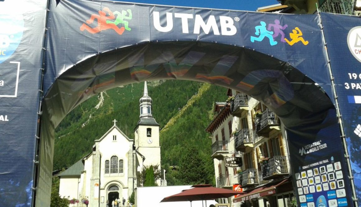
I arrived at the final checkpoint in Les Houches and swiftly transitioned through. Thinking ok, good, only nine flat kilometres left to do! Was I wrong! The track was undulating all the way into Chamonix and it was hot in the valley despite being in the shade of the trees for most of the way. It passed in front of the rocks at Gaillands and then onto a minor road. The end was within my grasp but I couldn’t run as much as I would have liked as it was just too damn hot so a power walk would have to do! I turned into the main streets of Chamonix and made myself run faster overtaking others in the meantime. The atmosphere was amazing as shoppers, cafe dwellers and spectators were clapping and cheering me as I made my way towards the end. I rounded the corner and there it was, the finishing line. My friend, Paul joined me taking photos of the last 100 meters and as I crossed the finish line, gave me a big hug. I’d done it! I needed a drink!

The unfinished business from last year was completed. It wasn’t pretty nor was it fast, but I’d done it! That made me happy and I felt the tears welling up in my eyes with the relief of having made it!

I collected my gilet, which after DNFing last year felt great. Even though jokingly it does resemble a bin bag, it’ll still take pride of place in my wardrobe.